Showing posts with label Half Marathon. Show all posts

Monday, 27 January 2014

Lion of Africa 21.1

Less than a week after the serious climbs of the Kloof Nek Classic sees the Lion of Africa Half Marathon. 

The route is hilly and covers similar areas to the Hohenort 15km. The organisers have made several improvements over the years to prevent congestion at the finish between the various races happening at the same time. The 10km is not a flat race but the hills are not too bad and first half is quite flat

The Lion of Africa event comprises a Half Marathon, 10km road race and the Philip Rabinowitz 10 km Walk, as well as a 5km fun run. The race walk is named in memorial of Philip Rabinowitz (1904-2008) the fastest 100 year old to sprint 100m [Wiki]

Lion Of Africa 21 Elevation Profile

Tuesday, 30 November 2010

Vital Lourensford Half Marathon

UPDATE: The traffic congestion was a bit of nightmare, people who left Cape Town by 5AM could not get to the start on time, some even an hour after the race had started. I feel sorry for the club and organisers no one goes out to cause problems like this, but expecting people to leave their house at 4AM or earlier for a 6:30 race is a bit of an ask just because of traffic and not distance.

The route elevation this year will be different as the entire half marathon route happens on the Lourensford Wine Estate (not on the sports field as in previous years). The flyer description says the first 3km are tough and the route is all off road/jeep track I assume. 

I am happy see the dam still features as well as Champagne Corner. I am bit concerned about the hill climb between the 8-9km mark, but I am still thinking of the old route. 245 meters was the highest we climbed last year. 

Lourensford Half Marathon Route Elevation.jpg
2009 Elevation Profile
I think it is great that the organisers are trying a new route and hope the parking situation is not a nightmare. Quite a heavily advertised race and entry on the day, so I bet there will be lots of people.

Flyer Route Description:
The 21km and 10km are off-road all on Lourensford Wine Estate. The two routes follows the same initial course with the first 3km challenging followed by most scenic views. The 10km meanders back mainly downhill and level running to the finish while the 21km continues contouring along jeep track and farm road along the foot of the Helderberg, passing Brinksburg dam including Champagne Corner. Another hill climb between 8 – 9km marks – the second half mainly downhill on easy forest and farm road. Please note that the surface of this route is not safe for wheelchairs and strollers. The 10km Walk follows a different course, relatively flat and easy, through the beautiful Wine Estate with an initial 2km tar section, the balance on good farm road.

Monday, 1 February 2010

Red Hill Marathon

One mistake I am glad I made was to do the Red Hill Marathon as my first marathon last year. I remember running up the Scarborough side of Red Hill and people asked me how many marathons I had done and they said I was crazy doing it as a first one, my reply was only to say “Hey pal I am still running it”. It was a pity by the time I got past 30km I was running less and less. Why running it first was a mistake is that people who know me know I have slight OCD tendencies. So now I am stuck having to run it every year that I am able from now on.
33%The percentage increase in the number of runners doing the marathon in 2010 compared with 2009. Fish Hoek Athletic Club must be doing something right.

I also like the idea of having an escape route option of the 6km shorter 36.3km Red Hill Classic and not taking it. This year I noticed a guy at the t-junction asking one of the marshals if he could down grade from the 42.2km to the 36.3km but never got to see what the outcome was.

Slangkop Light House
The Red Hill route is amazing. A bit of a slow start from the Fish Hoek sports complex, then onto the Kommetjie Rd, up Slangkop hill looking down at the Slangkop lighthouse.

I try to run in the middle of the road on this stretch as the camber it quite pronounced.


At the top of Slangkop is the start of a long speedy downhill, through Misty Cliffs to Scarborough, famous for the Camel Rock. Passing though Scarborough is a sneaky uphill up until the t-junction where the race splits between the Red Hill Classic and Marathon.

The out and back section towards Cape Point is mostly 3km of downhill. At the turnaround you are at the lowest point and the uphill does not stop until just before the 30km mark. The top of Red Hill was one of the best water stops ever, sponsored by a coffee shop.

It was too bad that I really was not up to eating muffins only had a slice or two of oranges. I could see that I was faster this year by the options available, last year by the time that.

Running down Red Hill gets to work some different parts of the body. I managed to get to the 30km point faster than Bay to Bay which was a good suprise.


At that bottom of Red Hill it is mostly flat until the Fish Hoek circle. At this point it becomes a mostly mental race.


There are 19 avenues that you need to run past, I like add 1 in my head and count them up one by one as percentages, counting 5%, 10% … 95% each time of cross an avenue. Before you get to 20th avenue you go off the main road and join up with the field. Getting onto the field is not the end there is quite a bit of running until you get to the finish. This year was well organised, plenty of everything: cold water, marshals, scenery and good weather. The only annoyance was the congested start. There definitely were much more people running this year.

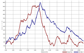
Red Hill Marathon route elevation profile and Google Earth route KMZ.
Red Hill Marathon Profile - Click to Enlarge


Wednesday, 10 December 2008

Two Vineyard Races

Grape Run versus Run Walk For Life New Balance 21

On the 6th of December 2008 I run the RWLFNB21 (The really need to something about the name of the race). The route ran though Lourensford Wine Estate most of it was off tar. It got me thinking about comparing The Constantia Valley Grape Run Half Marathon my time was 1 minute less for the RWLFNB21 but there is no way I ran as hard for it as I did on the Grape Run. I also was far less tired. When I overlaid the elevation profiles of both the races I think I discovered why the Lourensford half felt easier than the Grape Run Half Marathon.

Grape Run RWFL New Balance 21

The first thing to notice is that they both start at roughly the same altitude and the Grape Run is about 20 meters less climbing. I believe the Grape run is harder because the up and down hills are far more steep and the gravel roads and the running is more uneven. I was quite impressed by the well kept dirt roads of Lourensford. On big thing that I have to commend the RWLFNB21 organisers for was the entry process. What a pleasure being able to arrive at 6:10 to enter and pay while still having enough time wait at the start line before the starting pistol. The day was hot really hot. The route did seem to provide quite a bit of shade even though it meant doing a repetitive loop. Next time I will not take this race so seriously and actually swim in the dam.

Here is the kmz file Run Walk For Life 21.kmz

Sunday, 31 August 2008

Knysna Half Weekend

Ah the Knysna Half Marathon, ok I have done it. By the “West Knysna virus” (as I called it) I got the Monday following along with a whole bunch of other random people make me a little hesitant to do it next year. I was told it was going to be crowded I just never really understood. For some reason I thought it was going to chilled like the Outeniqua Half Marathon which I rate as a must do. The effort/wait and queue to pleasure ratio was not that great. I did have fun on the weekend but it was hard work. Also that down hill killed me, I thought the magazine was playing it safe by calling it a mine shaft. A friend of mine baled because of the downhill.

The concept is good. Cold morning, gas heaters, cup of coffee, strip your warm clothes and dump everything in a truck that will hopefully meet you at the end. Just it has just got really popular and it has its plus side, some people run it as their first half. Others only run the half as the only race they do the whole year.

The route profile is interesting at some points I apear to be below sea level.


KMZ of the route.

Thursday, 1 May 2008

Safari Half Marathon 1 May 2008

This is my nemesis race. In 2006 it was my first half marathon. The weather was really bad. Everyone I know that ran it in 2006 also mentions the bad weather. Trees had blown over because of really strong wind there was also a bit of drizzle. I remember how my running vest was being blown around and my race number almost tearing off. I really was not a happy running. So after 2 hours and 45 minutes I finished it in total pain. Later I discovered I was wearing the totally wrong shoes and this was turning point that made things better because it helped me get the right advice.

2007 was a far better race I was fitter than the previous year but just did not manage to do a sub 2 hour race. I had to settle with 2:05. The weather was much better and I enjoyed the race.

This year the weather was amazing a bit of wind but nothing too intense. From the start I knew it was not going to be my day my legs felt empty (just too much racing for me lately). So I adjusted my goals for the race and ploughed through it. I eventually finished in 2:20.

Last Saturday I ate the tail, today I was the tail; a bit of a humbling experience.

Case of the missing tent

When I got to the finish it was a bit stressful I was responsible for the club tent and when I got the where I left it on the field it was gone. I was a horrible feeling. Why would someone want to steal a branded tent? My wife got the announcer to ask if anyone knew anything about it but, as usual the announcers echoing request did not carry to the whole of the field. Thoughts of having to go to the police station to report it and the shame of being the guy that lost the tent.

Then out of sheer luck my Colleen went to throw something away the saw two club tents in their bags; a black tent bag and a blue VOB one underneath it. Someone in their wisdom decided to move it to this location – really annoying and stupid. At least it was stupidity (a world wide phenomenon) and not crime (that South Africa is supposedly notorious for).

The black tent bag with the black handle was not collected or stolen the whole time we were there and we stayed there a long time. We did try to notify the owners of the black tent but I doubt it was heard everywhere on the field.

Here is the route kmz file: Safari Half Marathon (Click to open in Google Earth)

View Larger Map

and the route profile:
Safari Half Marathon Route Profile

Photo at the finish:

Wednesday, 30 April 2008

Milkwood Half Marathon

On the 20th of April was the Milkwood 21 race. This race has a special significance for me as the first race I ever did when I started running was the 10km route. Then last year it was the first race I managed to complete in under 2 hours.

The start was a bit cramped but this race is so popular it was not too bad. I took the Slangkop hill a little faster than I thought I would but that might have been because I ran with Thomas also a VOB member for the first 9km and then let him race off while I played it safe. I wanted to improve my time for the route which was still a PB.

The route is really amazing and the weather was cool with no wind. At the turn around at Camel rock I was feeling strong. I like routes that double back on themselves because you can shout out to the faster people and get support from the people behind you. It also helps to know that there are people behind you. In the end I managed to better my time to 1:55:21. The best thing was that it felt easier than last year and my average heart rate is also lower.

Here is the route kmz file: Milkwood 21km
and the route profile:
Milkwood Route Profile

Tuesday, 29 April 2008

Outeniqua Half Marathon

Last weekend we managed to go with other VOB members to George for the 2008 Outeniqua Half Marathon. The route was great lots with lots of indigenous forest and vines. We arrived quite late at the dam only to discover that the start was not where we parked but a little over a kilometer away across the dam wall. So we raced off to run to the start line. I was about 400 meters from the start line when I heard the race start count down and pressed start on my watch. Normally this would have totally stressed me out but I managed to focus on getting to the start line. When we got the start line no one was there, it was strange I kept running and met the back markers. It was great in a way passing people in a way that I have not ever done before. I was running way faster than I normally do at the start but the interesting thing was that my heart rate was way lower than it normal. My wife had a buck cross her path on the route; great seeing wildlife on the route and the unique sounds of Loeries in the trees above.

Eventually I managed to catch up to the 2 hour crowd, fortunately before the first down hill. The route goes through the forestry campus; it reminded me of a place I ran in The Netherlands with small roads and people riding bicycles. Then the route started to get fantastic with high trees and vines. The down hills were really steep with two tough up hills, I walked a bit on the first hill but found the second hill not as bad even though it was longer. I remember saying that is a pretty looking bridge and then realized that bridges cross rivers and have a valley on the other side. Then a few bumps and then a down hill of over 7 km. On the way downhill you don’t see much until you get to a point where you see an amazing view of the lakes, river and coastline. The last 3 km was tough I really pushed going down the hill and the last few bumps on the route seemed really hard.

Here is the Outeniqua Half Marathon 2008 kmz file for the route that can be viewed in Google for those who are interested (The real official route is 400m shorter).

And this is the route profile.

Outeniqua Half Marathon route profile